
By Harold Eyster, with thanks to Julia Craig, Roxanna Delima, and Kai Chan for comments on an earlier draft
After spending four years running the streets in Cambridge and Boston, Massachusetts, Vancouver was a shock.
The streets of Cambridge are laid out at odd angles and change names every few blocks. Getting from A to B never involves a straight line, and figuring out how to navigate the city took years of getting completely lost on a regular basis.
 |
| The chaotic streets of Cambridge, MA. Source: Cambridge Geographical Information Systems https://www.cambridgema.gov/~/media/Files/GIS/allmapsandatlases/CambridgeBaseMap18x24.pdf |
In contrast, Vancouver’s streets are laid out in a well-organized grid, complete with numbered avenues that always face East/West to make it easy to know where you are, what direction you’re facing, and how to get home.
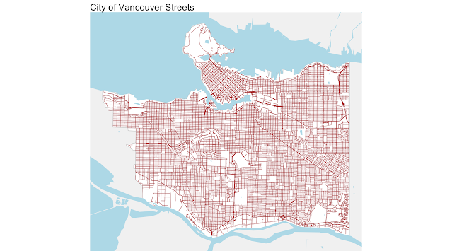 |
Source: Jens von Bergmann https://doodles.mountainmath.ca/blog/2018/06/04/vancouver-streets-and-lanes/ |
While some might appreciate the order of Vancouver’s streets, I found them boring and uninteresting. The order and regularity of the streets failed to pique my curiosity. I had enjoyed the challenge of navigating Boston’s streets. Indeed, of 100 global cities analyzed by Geoff Boeing, Vancouver showed the fourth-highest spatial orderliness. Meanwhile, Boston sits near the bottom of the list.
I needed a new plan for motivating my running and exercise, which was essential to my well-being. I remembered how years ago, while living in Boston, I accompanied my friend Philip Kreycik on a run around Cambridge, Massachusetts. This wasn't just any run though—it was a run around the borders of the city, and his final run on his quest to run every road in Cambridge. During our run, Phillip explained how running every street had really brought the city alive for him and brought new understanding of how the city worked.
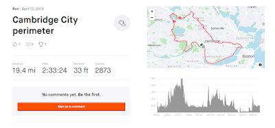 |
| Map of our perimeter run of Cambridge, MA |
Inspired by Philip, perhaps I could do the same in Vancouver?
So I drew on my GIS experience and found some Vancouver street shapefiles, printed out a map of Vancouver's streets, and started my quest to run all of them. This new quest encouraged me to explore, and made each of my runs deliberate, producing new scenery, smells, and adventure—even if all the streets were on a grid.
Each night, I would return to my apartment and use a highlighter to mark the new streets I’d run.
 |
| Closeup of the highlighted map that hung on my bedroom wall |
These runs revealed hidden treasures: ripe blackberries, blooming trees, a delicious apple tree, sightings of Black Oystercatchers, or unexpected parks and history.
While I was filling in my map, I was in the midst of working on a review of theories about why people do what they do. Many of these theories posit the importance of psychological and cognitive needs. One such need that cropped up in many papers was the need for exploration. Though it goes by many names—promotion focus, pleasure promotion, mental mapping—researchers tend to agree on one thing, that it is important to people to explore, to become familiar with the unknown, to chart new territory and connect disjunct sets of knowledge.
 |
| Big Leaf Maple flowers are easy to miss, but worth a second look. |
Why was I doing these runs? Satisfying this need for exploration seems to be part of the answer: the excitement of finding what surprises lay on the road ahead or around the next corner, and fitting this new piece of knowledge into my mental jigsaw puzzle of the city. It was fun to see my academic work beginning to explain what I had at first viewed as an entirely orthogonal pursuit.
Just as my academic work was informing my runs, my runs often provided opportunities for academic breakthroughs. What would start out as a break (that I sometimes did not feel like I had time for), turned into an opportunity for deep thinking and reflection. Sometimes, taking a step back—or a sprint forward, as the case may be—was all I needed to bypass a cognitive bottleneck.
Once, while running along Bailie street, I suddenly realized that I had parametrized a beta distribution entirely wrong. Another time, after spending a few hours struggling to write the conclusion for my dissertation, I went out for a run. My dissertation chapters were wide-ranging and interdisciplinary, and finding the higher level contribution that transcended all five chapters was proving difficult. But out on my run, it all suddenly became clear. As I ran, I started writing the conclusion in my head. When I got back to my apartment, all I had to do was transcribe it to my computer.
As 2021 approached, I had run most of the streets near my apartment. Those remaining were quite far away—getting to them was requiring longer and longer runs. As COVID-19 pandemic kept me away from my family’s usual New Year celebration, I decided to kick off 2021 by completing a longstanding personal goal—my first 100 miler. I started at 4pm, it started raining at 9pm, and by 12:00 AM, it was pouring—a quintessential Vancouver run. Though I was thousands of kilometers away from my family, I felt a sense of belonging as I jogged through these increasingly-familiar streets. Wet, cold, and tired, but home for the holidays.
 |
| The route of my New Year run |
 |
| A slide from my Zoom dissertation defense. Photo credit: Sophia Winkler-Schor |
On a warm July morning this past summer, I defended my dissertation. Directly afterward and still filled with elation, my housemate and fellow runner, Krishanu Sankar, and I dashed out the door and ran south to a road that I had missed in the previous years—the last that I had yet to run: Minto Crescent.
 |
| Minto Crescent: my last road! |
Only 350 m in length, it marked the end of my quest. I had completed my goal of running all 1557 km of streets in Vancouver and defended my PhD on the same day. They had proven to be a complementary pair of goals.
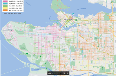 |
Map of Vancouver made by Roxanna Delima showing the streets I ran in Vancouver. |
Unfortunately, the completion of these milestones did not end as I expected. Just a week prior, the man who had inspired this whole endeavor back in Cambridge, Philip Kreycik, went missing in the Bay Area, while out for a run. Searchers would later find his body. I had been looking forward to writing to him and telling him how he had inspired me to run Vancouver's streets, and how thankful I was for this inspiration. His untimely passing made me realize that I should have reached out to him much earlier to celebrate the journey, instead of waiting until I’d finished.
 | |||
| Bushtits were frequent companions on my runs. |
As I reflect on my experience a few months later, I’m struck with how essential this running journey was to my PhD: it provided a perfect complement to the often-stressful graduate experience. I am thankful for the incredible encouragement I had throughout my PhD and while running all the streets in Vancouver. I have also come to appreciate the importance of cherishing whatever place I’m situated in, and learning to look past the gridded map to see the beauty of the individual trees, streets, and neighborhoods.

CHANS Lab Views by Kai Chan's lab is licensed under a Creative Commons Attribution-ShareAlike 4.0 International License.
Based on a work at https://chanslabviews.blogspot.com.
No comments:
Post a Comment